
The Last Alarm Is Not the First Warning
The new warning towers on the Guadalupe River worked this July, but they are still only the last line. This piece is for the people who run and design parks, camps, campgrounds, and waterfronts, on what a first flood warning actually is and who it has to reach.
What the Texas river towers can and cannot do, and the warning layer that public spaces still need.
By David Cook, CEO, Code Blue Corporation
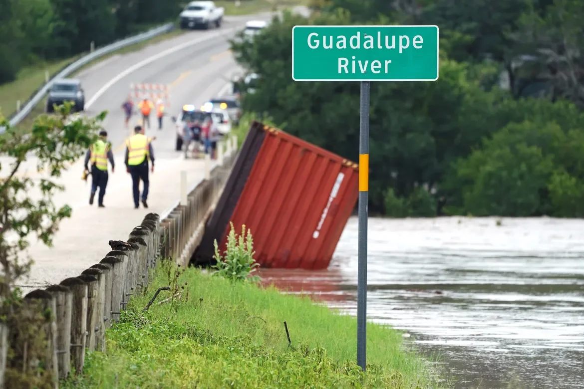
In the early hours of July 16, 2026, towers on the Guadalupe River did what wasn’t possible on a similar night the year before. They helped people get to safety when river conditions changed.
Water reached a sensor. A siren and a voice told people to run to higher ground. Lights pointed uphill. Families left an RV park before the flood tore through it. Before I go further, one disclosure: I build warning devices for a living. I had no part in anything on the Guadalupe, and I was not there. Read my opinions with that in mind.
I take that night seriously, and I take the people who designed those devices seriously. A year earlier, a flood on the same river killed more than a hundred people, including twenty-five children and two counselors at Camp Mystic. This July, towers on the bank woke the families sleeping near it in time to leave. Upper Guadalupe River Authority sirens, new gauges, a public dashboard and a privately funded network of site towers add up to something real. They are the first serious answer Kerr County has given that river.
The conversation has already moved to “we have towers now.” That is the sentence I want to slow down. The last alarm is not the first warning.
What the First Night Taught
The 2025 flood is easy to explain. A stalling storm put a year’s worth of water into a limestone valley that does not soak. The Guadalupe at Hunt, TX went from a stream you could wade to a wall. Youth camps and RV parks packed the banks because that is where people want to be in July.
The professional alert system existed. The National Weather Service issued a flash flood warning at 1:14 a.m. County CodeRED and Wireless Emergency Alerts went to phones. But Camp Mystic’s rules had already taken those phones away from the girls and, except for a few senior staff, from the counselors in the cabins. Cell service on that stretch was poor on a dry night. The camp had a loudspeaker. It was not used to warn the campers. The written instruction in the cabins was to shelter in place. Investigators later said there was still time, after the warning, to walk the short distance to high ground.
This is the same shape as every community-safety argument worth making. A path to professionals is necessary, and it only covers what happens after the call. The first minutes belong to the people already on the site, including the people who do not have access to the public alert channel.
What the Second Night Bought
By July 2026, the valley had memory and hardware. New outdoor sirens stood west of Ingram, TX. A private company, formed after the first flood, had put roughly a hundred towers along the North and South Fork, paid for largely by camps and families who live with that river. River gauges were pulled onto a public dashboard. People left earlier. Deaths on the second river rise were a fraction of the first.
The people who put those towers on the bank were solving a real problem. How do you wake a sleeping cabin without crying wolf all summer? Hill Country rivers jump a couple of feet after ordinary storms. A sensor that fires on every rise will be switched off by July. A sensor that waits until water stands between the bunks and the river means the alarm is true. That is a serious engineering choice. I understand why they made it.
It is the wrong choice if it is the only choice. Those site towers are last-line devices. They are placed so that water must hit the sensor before it hits the bunks. When they work, they work like a hotel fire alarm. The fire is already in the hallway.
A Hill Country flash flood is not a hallway fire. The real warning for a given site comes earlier. It is a two-foot river that becomes a four-foot river in twenty minutes while the water is still in the banks. That rise, confirmed by the gauge upstream and the rain in the headwater, is the first warning.
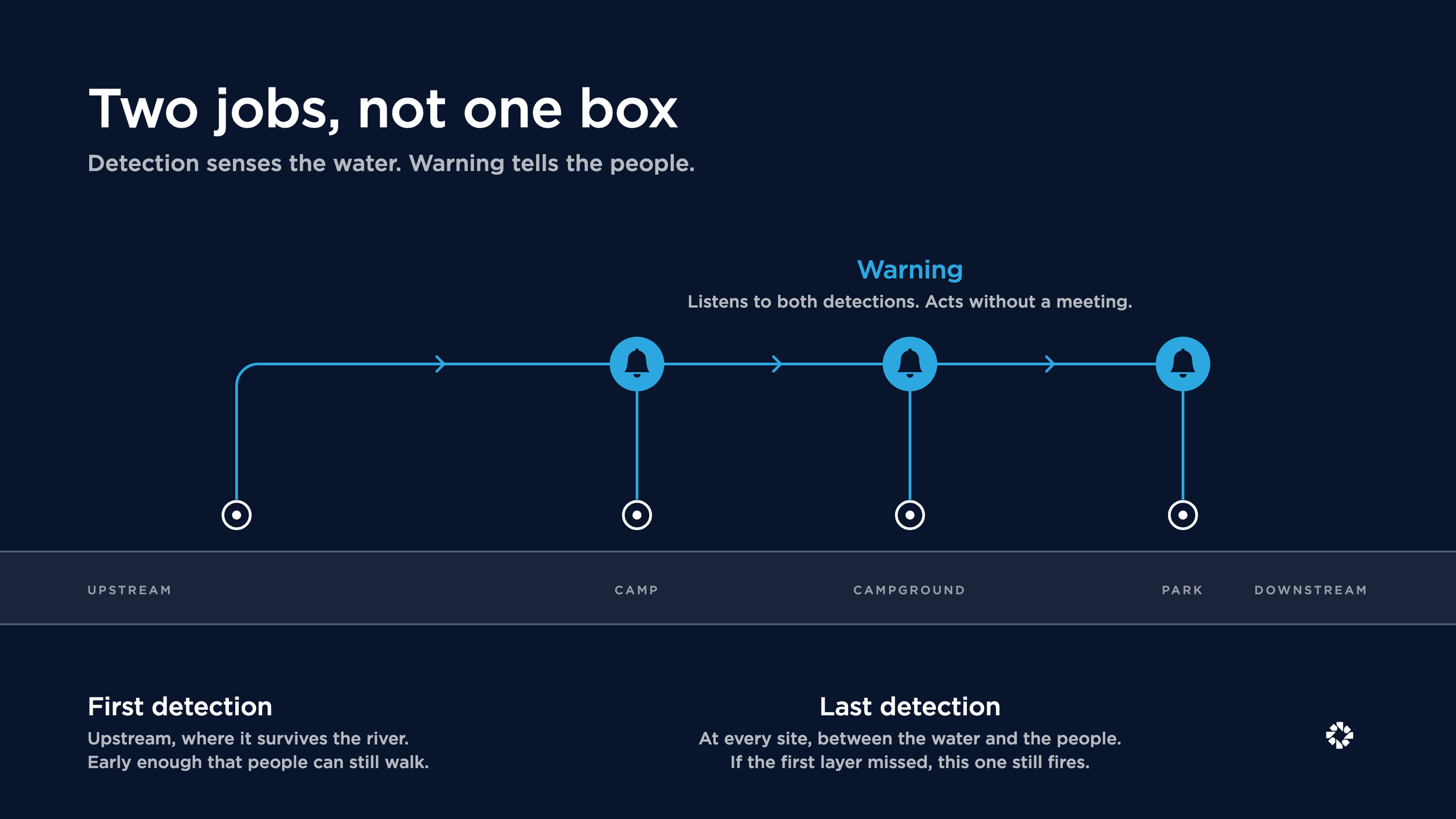
Flood Detection vs. Flood Warning: Two Jobs, Not One Box
The towers already talk to each other. When one fires, it relays the alarm along the line, and the network is built to keep working after power, cellular, and internet have quit the valley. That is real engineering, and it solves the hardest half of the problem. The alarm travels.
Placement is the half still open. The sensors in that network stand in the floodway, at the site, between the bunks and the bank. The first fact the network can generate is water where it shouldn’t be. Relay spreads that fact fast. It spreads it late.
Detection and warning are different jobs, and they deserve different ground.
The first detection has to survive the river. Stage and rate of rise belong on a bridge soffit, a canyon wall, a high bank upstream. That layer is allowed to be early. Its job is to tell every downstream device the river is rising while people can still move.
The last detection belongs on every local device, exactly where the towers put it today. A wet switch or the equivalent between the riverbank and the people at that site. If the first layer missed, this box still screams. It may be destroyed. That is acceptable because it has help.
Warning is a third function. It has to be readable in daylight and hard to sleep through at night. It listens to both detections, and it acts without a meeting. County sirens that wait on an activation plan are a public voice, and the valley needs one. A device that changes state at 3:32 a.m. without a human’s approval is a different instrument.
The towers gave the Guadalupe a voice that carries. The next layer gives it something to say, earlier. One river, one fact, delivered while the water is still in the banks.
A Light People Can Read
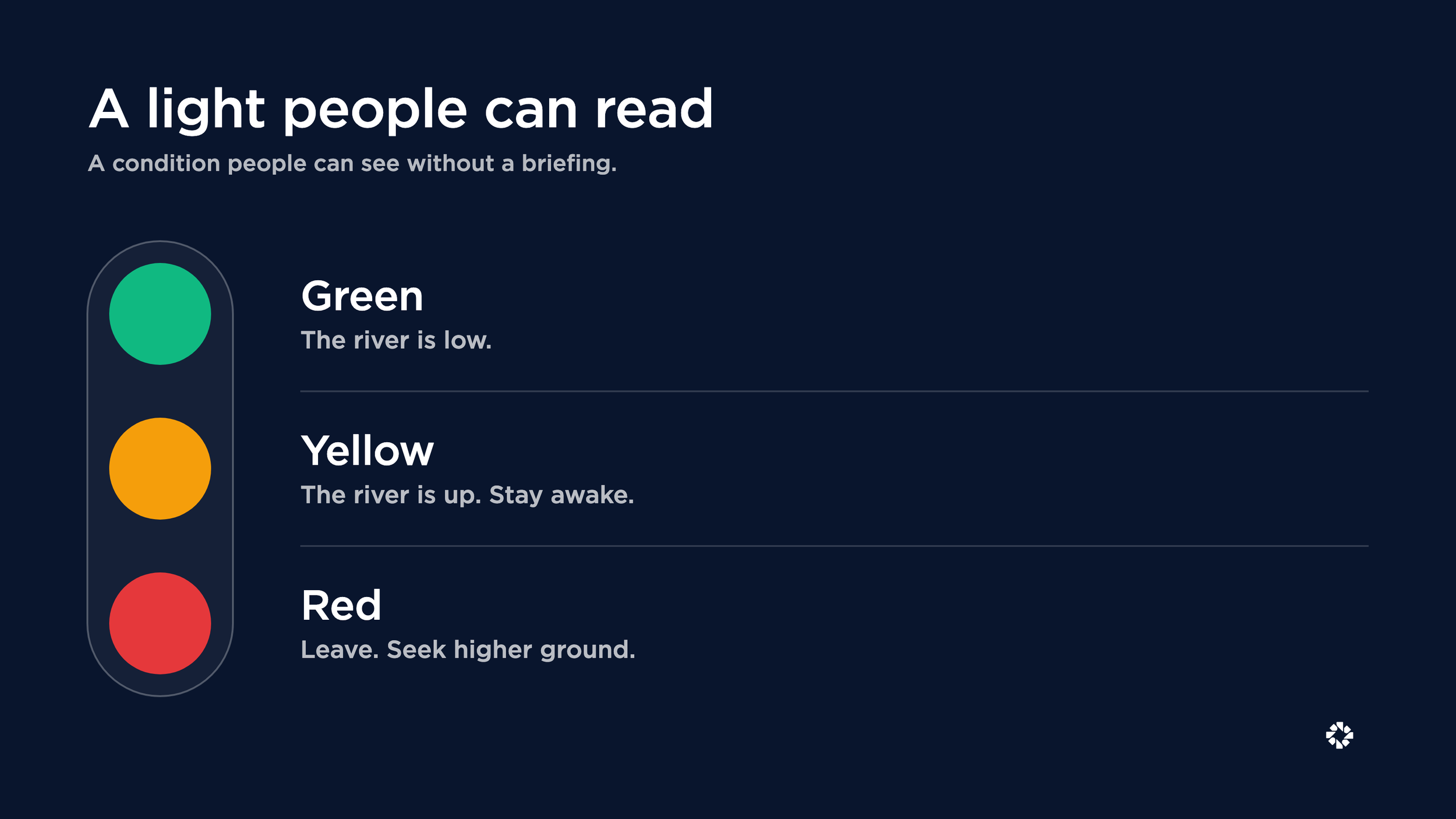
The missing component is a condition indicator people can read without a briefing, and it is better than a louder siren. Green when the river is low. Yellow when the water is up but the rate of rise is still ordinary for that reach. Red when the rate predicts a crest beyond what the riverbank has historically experienced. Yellow is how you tell the truth without crying wolf. Red is how you take the decision back from the person who is still hoping the river is safe.
Each color change is a simple notice, sent downstream as well as at the site. Green to yellow. The river is up. Stay awake. Yellow to red. Leave. Red alerts travel. If one river station goes red, the next station and those at the parks below it also go red. The warning moves faster than the river.
Red is the only moment the voice has to shout. Seek higher ground. A light points to the path. People get information while they can still move.
Most of this gets decided at the drawing stage. Where the first detection belongs is a siting question, answered upstream of the property line. Where the light stands is a sightline study. Can a family at the tent pads, the swimming hole, and the trailhead see it, in daylight and in the dark? The route uphill is wayfinding, graded and lit so a visitor can follow it at a run. And the rally point deserves the same program attention as the pavilion: shelter, a roster, a radio. A landscape architect who carries those decisions into schematic design builds the warning layer into the land itself, at drawing-set prices, before the first guest arrives.
Where does your own site stand on what its people can read? Take the Community Safety Readiness Assessment. Nine questions, about two minutes, no sales call required to see your results.
The People After the Sound
"Flood danger. Run to higher ground" is the right first sentence. The next job is the count. In 2025, people staying put was only half the problem. Nobody could say who had left. A light that points uphill should end at a place with a roster, a radio, and a way to tell the next site what's happening.
Rescue still has to find people. Public cellular failed on the first night, and the phones locked in a camp office could not have used it anyway. So a site needs its own way to carry a voice and an image after the public network quits, and that is how the owner of the land, the people standing on it, and the crews driving toward it end up working from the same information. Knowing who is on which roof is the point.
I wrote earlier this year about the five things a connected system does in the first thirty seconds after someone reaches for help. The same logic holds on a riverbank. The response is only as good as the layer that carries it.
Who the Valley Forgot
The new hardware followed the checks. Youth camps first. Then hotels and campgrounds. That’s rational for a company that has to get paid. The public build has its own gaps. The river does not pay invoices.
State parks, city parks, unofficial swimming holes and low-water crossings are where the next visitors will be. Guadalupe River State Park is written into the flood-impact ladder for the Spring Branch gauge. Pedernales Falls State Park watched a wave go from a thousand cubic feet a second to ninety thousand in about three minutes and closed trails because staff were watching. Garner State Park put seven feet of water over the dam and accounted for campers because people on the ground would not stop talking. Those are public places we invite families onto, knowing the amenity can be a hazard.
A visitor is not on CodeRED. A nine-year-old at camp is not allowed a phone. A day user is already in the water. Designing around “they will get the text” fails the people the parks were built for.
Permission While Leaving Is Still Walking
In 2025 people hesitated because the river did not look like that yesterday and nobody had authority to move a cabin. In 2026 memory plus an audible device gives that authority. Memory fades. Next July’s visitors will not have 2025 in their bones.
A community grants permission on a Tuesday in June with a shared, physical fact. Something you can see in daylight and wakes you at three in the morning. A dashboard a director might sleep through does not do this job. The professionals are coming. They are not there yet. Supported people do more than unsupported people. That is true on a beach with a life ring. It is true on a river with a cabin door.
Community Safety is the layer of a space that lets the people already in it act on a shared fact in the minutes before professional help arrives. I wrote about the permission half of that idea, and the rescue that taught it to me, in Permission to Act.
I do not want the towers taken out. I want them demoted to what they are. The last shout at a site that should already have watched the light go yellow, then red, when two feet became four. Build the first detection so it outlives the flood. Let green, yellow and red indicators travel downstream without a meeting. Take the same stack to the parks that cannot write a private check.
Kerr County proved that a loud object on the bank can save the people who hear it. Making the river one community is the part still in front of us. The sirens rang. The rest of the work is waiting.
Three Questions Park and Site Leaders Ask
-
Detection senses the water. Warning tells the people. They are different jobs, and a system that keeps both in one box standing in the floodway will do both jobs late. Detection belongs upstream, where it can be early and survive. Warning belongs everywhere people are, and it should listen to more than its own sensor.
-
A condition a stranger can read without a briefing. Green, yellow, and red, visible in daylight, loud enough to wake a sleeping cabin at night, pointing to a place where somebody takes a count. If the only signal is a text alert, the visitors who never joined the county’s list are left out.
-
No. Weather service warnings, county sirens, and phone alerts are the public voice, and site towers are the last line. The missing layer usually sits between them. A first detection upstream that tells every downstream device the river is rising while there is still time to walk.

David Cook, CEO
Code Blue Corporation
Safe Community Spaces is a biweekly newsletter from David Cook at Code Blue®. One idea about Community Safety, every two weeks. Subscribe to the newsletter.